El Nino Is Back. What NOAA's New Forecast Does and Does Not Tell Us About Winter
NOAA says El Nino conditions have returned and could strengthen by winter, but scientists caution that the climate pattern shifts odds rather than guaranteeing local weather outcomes.
Save Article
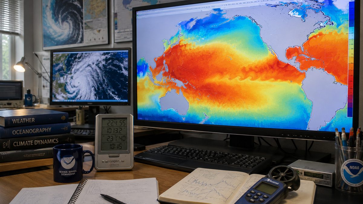
Ocean temperature patterns in the Pacific help forecasters understand how El Nino may shape seasonal weather odds. Editorial illustration by TheDailyGlobe.
Key Facts
- NOAA says El Nino conditions are currently present in the tropical Pacific.
- The agency issued an El Nino Advisory on June 11.
- NOAA expects El Nino to strengthen into the 2026-27 Northern Hemisphere winter.
- Forecast guidance cited by NOAA shows a 63 percent chance of a very strong El Nino during November through January.
- Scientists emphasize that El Nino changes weather probabilities rather than guaranteeing local outcomes.
A stretch of warmer water thousands of miles from most Americans can influence weather patterns across large parts of the planet. That idea can sound surprising, but it is one reason scientists pay such close attention to the tropical Pacific Ocean.
This week, NOAA reported that El Nino conditions are present and issued an El Nino Advisory. The agency also said the climate pattern is expected to strengthen as the year progresses, with forecasts indicating a meaningful possibility that it could become very strong by the heart of the 2026-27 Northern Hemisphere winter.
The announcement does not predict exactly what the weather will be in any specific city. What it does signal is that one of the world's most important climate patterns is becoming active again, potentially influencing seasonal weather odds in the months ahead.
What Changed in the Pacific
El Nino develops when sea-surface temperatures in parts of the equatorial Pacific Ocean become warmer than average for a sustained period. Those temperature changes can affect the atmosphere above the ocean, altering wind patterns and influencing weather systems that extend far beyond the Pacific itself.
According to NOAA, current ocean and atmospheric conditions now meet the criteria for El Nino. Forecasters also see signs that additional warmth beneath the ocean surface could help support further strengthening in the months ahead.
Scientists do not rely on a single measurement when making that determination. They examine sea-surface temperatures, subsurface ocean heat, atmospheric patterns, and computer models that simulate how the climate system may evolve.
Why People Pay Attention to El Nino
El Nino matters because it can influence seasonal weather patterns across multiple continents. Farmers, water managers, emergency planners, energy providers, and forecasters often monitor its development because shifts in temperature and precipitation can affect planning decisions months in advance.
The exact effects vary by region and from one event to another. Some areas may see increased chances of wetter conditions, while others may face different temperature or precipitation patterns than they would during a neutral year.
For most readers, the practical takeaway is not that a specific outcome is guaranteed. Instead, it means that forecasters are seeing a climate signal large enough to influence the odds that seasonal weather develops in certain ways.
What the Forecast Does Not Prove
One of the most common misunderstandings about El Nino is treating it as a local forecast. NOAA's advisory does not tell residents of any city exactly how much rain they will receive, how much snow will fall, or whether a particular storm will occur.
Climate patterns operate on a broader scale. El Nino can tilt the probabilities toward certain outcomes, but local weather remains influenced by many other factors. That is why scientists are careful to separate seasonal tendencies from specific forecasts.
Even when forecasters have high confidence that El Nino is present, uncertainty remains about how strongly its effects will appear in different regions.
The Biggest Questions Still Ahead
NOAA's forecast points toward strengthening conditions, but several important questions remain unanswered. The first is how strong the event ultimately becomes by winter. Forecast models indicate a range of possible outcomes, even if stronger scenarios currently appear plausible.
Another question involves regional impacts. The climate pattern may influence broad weather tendencies, but those effects are not distributed evenly. Some areas may experience more noticeable impacts than others, and those details often become clearer as winter approaches.
What Comes Next
The next several months will provide additional clues about where this El Nino is headed. NOAA regularly updates its monitoring and outlooks as new ocean and atmospheric data become available.
For now, the key development is straightforward: El Nino has returned, and forecasters believe it may strengthen substantially by winter. What remains unknown is exactly how powerful it will become and how its influence will be felt across different regions. Those answers will emerge gradually as scientists continue tracking the Pacific Ocean's evolving conditions.
Reporting note: Reporting draws on NOAA Climate Prediction Center materials, agency monitoring data, scientific forecasts, and reviewed background reporting. This article was produced with AI-assisted research and reviewed by an editor before publication.