Weekend Storms Show Why Flood Alerts Matter Before Roads Look Dangerous
Severe-weather forecasts and Texas park closures show how heavy rain can turn ordinary weekend plans into safety decisions before flooding is obvious.
Save Article
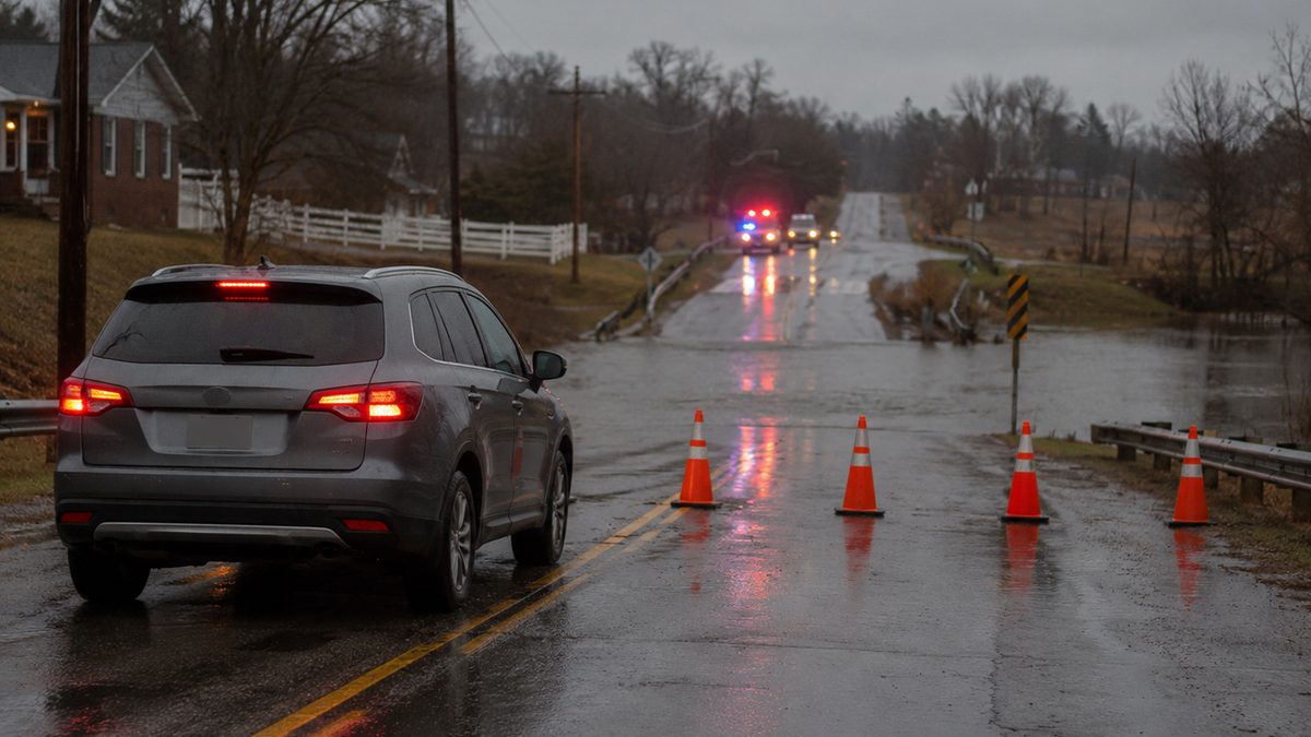
Flood alerts can affect ordinary weekend travel before conditions look dangerous. Editorial illustration by TheDailyGlobe.
Key Facts
- The National Weather Service described areas of severe thunderstorms and excessive rainfall through the weekend.
- Weather Prediction Center forecast materials covered June 6, June 7 and June 8.
- Local reporting in Texas described trail and roadway closures at Palo Duro Canyon State Park after heavy rain.
- Forecasts can shift as storms develop, so exact local rainfall amounts and impacts remain uncertain.
- Localized flooding risk should not be treated as a nationwide emergency, but alerts can matter quickly in affected areas.
A weekend plan can change fast when heavy rain moves in. A road that looked passable an hour earlier can become risky. A hiking trail can close before visitors arrive. A low-water crossing can turn dangerous before the water looks dramatic from behind a windshield.
That is the practical lesson behind the latest round of weekend storm forecasts and local closures tied to heavy rain. The National Weather Service described areas of severe thunderstorms and excessive rainfall through the weekend, while Weather Prediction Center materials covered forecast concerns across Saturday, Sunday and Monday. In Texas, local reporting described trail and roadway closures at Palo Duro Canyon State Park after heavy rain, with flash flooding concerns in the region.
Why Alerts Come Before The Worst Conditions
Flood alerts can feel easy to ignore when the sky is only gray, the rain is light, or the nearest creek still looks normal. But weather warnings are meant to give people time to act before conditions peak. By the time water is visibly moving across a road, a driver may already be out of good options.
That is especially true around low-water crossings, steep terrain, urban streets, small streams and recreation areas where runoff can collect quickly. Heavy rain does not have to fall everywhere to create a problem somewhere. A storm that parks over one area can make a local road, trail or park unsafe while another neighborhood nearby sees only ordinary rain.
The Texas closures offer a clear example. Local reporting described Palo Duro Canyon State Park closing trails and a roadway after heavy rain. For visitors, that kind of update is not just a park operations notice. It is the difference between driving out for a planned hike and knowing before arrival that conditions have changed.
What Drivers And Families Should Take From This
The larger point is not that everyone should cancel weekend plans whenever storms appear in a forecast. It is that people should treat flood watches, warnings and local closure notices as practical information, not background noise.
For drivers, that means checking the local forecast before leaving, not only after rain starts. It also means watching for road closure notices from local governments, transportation agencies, emergency managers and park officials. If a route includes rural roads, low-water crossings, canyons, creeks or underpasses, the risk can be more specific than a broad regional forecast makes it sound.
For families, the same logic applies to youth sports, camping trips, lake visits, park outings and long drives. A storm forecast may not mean the whole weekend is lost. But it can mean plans need a backup route, a later start, a different park, or a decision to stay off a road that local officials have flagged as unsafe.
Outdoor visitors should be especially cautious in places where terrain shapes the risk. Canyons, trails, washes and low-lying areas can respond quickly to rain, including rain that falls upstream or nearby. A trail closure may feel inconvenient, but those decisions are often made because conditions can change faster than visitors can safely react.
What The Forecast Does Not Tell Us Yet
There are still limits to what the current forecast can say with certainty. The National Weather Service and Weather Prediction Center can identify areas of concern and update risk levels, but the exact communities that see the heaviest rainfall may not be clear until storms develop.
That uncertainty matters. A forecast can correctly warn about excessive rainfall risk even if the worst impacts end up being scattered. Flash flooding is often local. One town may see road problems while another nearby misses the heaviest rain. That does not make the warning useless; it means readers should use the warning as a reason to pay closer attention to local updates.
It also means the story should not be framed as a nationwide flood emergency. The risk is practical and location-dependent. People in affected areas should pay attention. People outside those areas should understand the broader safety lesson without assuming the same threat applies to them.
What To Watch Through The Weekend
The most useful updates now will be local ones. National maps can show the general pattern, but local National Weather Service offices, emergency-management agencies, transportation departments, park systems and law enforcement often provide the details that affect real decisions: which roads are closed, which trails are unsafe, where water is rising, and whether storms are expected to repeat over the same area.
Readers planning to drive, hike, camp or travel through storm-prone areas should check again before leaving, especially Sunday as forecasts update. The key question is not whether rain is falling at home. It is whether the route, park, crossing or destination has changed since the plan was made.
Flood alerts are not meant to create panic. They are meant to buy time. This weekend’s weather risk is a reminder that the safest decision often happens before the water rises, before the cones go up, and before an ordinary road becomes the part of the trip people wish they had avoided.
Reporting note: Reporting draws on National Weather Service forecasts, Weather Prediction Center materials, local Texas weather reporting, and reviewed public-safety context. This article was produced with AI-assisted research and reviewed by an editor before publication.